You are here News and events News News Search news Search by year All2024202320222021202020192018201720162015201420132012 Tags - Any -3DABSEventsLand AdministrationAECAgileAgribusinessAgricultureWaterfallLocation-based analyticsBig Data AnalyticsGeospatial AnalyticsUrban analyticsPredictive analysisReal-time analyticsTransport analyticsAnalyticsData analyticsAppsMobile applicationsAppStudioArcGISArcGIS 10.5ArcGIS 10.6ArcGIS EnterpriseArcGIS HubArcGIS IndoorsArcGIS OnlineArcGIS ProArtificial intelligenceAsset managementInsuranceInsurance and BankingAugmented realityAustralian Bureau of StatisticsAutodeskBankingBIBig DataBIMBusinessBorder PatrolBusiness IntelligenceCadastreCalifornia CoastlineCitizen engagementClean energyCloudCloud computingCloud GISCollectorCommercialCommercial propertyCommunityContentCoronavirusCouncilCOVID-19Crisis CrowdsourcingDataRaster dataData visualisationDeep learningDefence and intelligenceDekhoDesignSpeculative designDigital constructionDigital engineeringDigital transformationDigital transformationDigital twinDisruptive appsDronesResourcesEducationGreen economyeLearningElectionElectorateElectricElectricityEmergency managementEmergency responseEmergency servicesEnergyRenewable energyEnergy, oil, gas and renewablesEngineeringEnterprise GISENVIEnvironmental managementEsriEsri AustraliaEsri Petroleum ConferenceEsri UCEsri Young Scholar AwardEsri Young Scholars AwardFederal governmentFinancial institutionsFinancial servicesFood securityForestryGasGDA2020GDA94Geo hubGeoAIGeoAnalyticsGeoBIMGeographic datumGeographic Information SystemsGeospatialGeothermalSolar eclipseGISGIS for schoolsGIS for urban and regional planningGIS in miningGIS in national government GIS in oil and gasGIS managerGIS server softwareGIS technologyGIS untuk perencanaan kota dan wilayahGIS web servicesGovernmentGovernmentMount AgungHealthHealth and human servicesHomeland SecurityIcon WaterIDLImageryImpact AwardsIndoor navigationPetroleumTransport and InfrastructureInnovationInsights for ArcGISLocation intelligenceOperational intelligenceInteractive mapsInternet of ThingsInternshipInteroperabilityIoTJack DangermondUtility networkJavaScriptNational SecurityPublic safetyPartnershipKerajaan Negeri SembilanOperational awarenessOH&SSmart communitiesSafe communitiesLand managementLaura DangermondLaw enforcementLive dataLive sensorsLocal governmentLogisticsMachine learningSupply chain managementMapping and chartingMapsMaritimeResilient communitiesMediaMicrosoft AzureMiningMining explorationOilOil & gasMobileMobile GISNational developmentNot for profitOpen dataOpen platformOz MineralsOzriUnited NationsPortsTrainingSustainable developmentState governmentSite ScanSAR ImagerySatellite imagerySAG AwardsRemote sensingPlanningUrban planningPERHAPIUnmanned Aerial VehiclesPETRONASProductsPublic sectorQueensland GlobeRetailUser researchROISaaSSabah Lands and Surveys DepartmentSAPSARscapeSensorsSmart transportSmart citiesSmarterWXSpatial data infrastructure solutionsStartupsStory mapsWaterSurvey123TelcoTelecommunicationsTransformationTransportTransportationTSFUIUnearthed ChallengeUser experienceUser interfaceUtilitiesUXUXGVirtual realityWeb GISWHO NUS student's urban planning project wins nationwide competition A National University of Singapore (NUS) student's passion for sustainable urban planning has secured him a ticket to the world's largest spatial conference – the Esri International User Conference (Esri UC) in San Diego, California. Learn more Mapping technology to give Asia's SCM industry world-class capabilities One of the world’s leading geospatial experts is in Singapore this week to advise the region’s logistics industry on how real-time mapping technology will help them achieve world-class supply chain capabilities. Learn more GIS technology lights up Singapore's utilities sector, says expert Bill Meehan, global director for Utilities at Esri – the world’s largest GIS technology company – was in Singapore to address the region’s top utilities organisations on the issue of spatially enabling their senior management. Learn more News Real-time mapping can tighten Australia's ports, says expert Real-time mapping technology used at a United States super-port could help Australia's national security agencies crack down on crime in the nation's major docks – according to a leading international specialist. Learn more News News channel maps driving offence hot spots Seven News has used GIS technology to reveal Queensland suburbs with the highest number of serious driving offences. Learn more News Earth's view unlocked at a touch A never-before-seen glimpse into the Earth has been revealed in Singapore at a leading geospatial event. Learn more News What's the big deal about Big Data? Any financial services provider can survive in the sea of Big Data. But don't let vital business and consumer insights float by. Learn more News Esri Singapore, Nanyang Polytechnic unveils first ArcGIS lab in Singapore Esri Singapore has signed a three-year partnership with the Nanyang Polytechnic (NYP), School of Information Technology. Learn more
NUS student's urban planning project wins nationwide competition A National University of Singapore (NUS) student's passion for sustainable urban planning has secured him a ticket to the world's largest spatial conference – the Esri International User Conference (Esri UC) in San Diego, California. Learn more
Mapping technology to give Asia's SCM industry world-class capabilities One of the world’s leading geospatial experts is in Singapore this week to advise the region’s logistics industry on how real-time mapping technology will help them achieve world-class supply chain capabilities. Learn more
GIS technology lights up Singapore's utilities sector, says expert Bill Meehan, global director for Utilities at Esri – the world’s largest GIS technology company – was in Singapore to address the region’s top utilities organisations on the issue of spatially enabling their senior management. Learn more
News Real-time mapping can tighten Australia's ports, says expert Real-time mapping technology used at a United States super-port could help Australia's national security agencies crack down on crime in the nation's major docks – according to a leading international specialist. Learn more
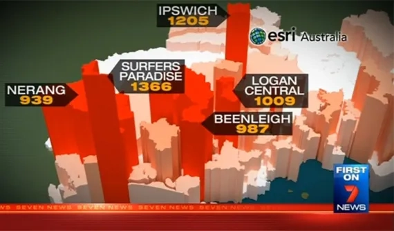
News News channel maps driving offence hot spots Seven News has used GIS technology to reveal Queensland suburbs with the highest number of serious driving offences. Learn more
News Earth's view unlocked at a touch A never-before-seen glimpse into the Earth has been revealed in Singapore at a leading geospatial event. Learn more
News What's the big deal about Big Data? Any financial services provider can survive in the sea of Big Data. But don't let vital business and consumer insights float by. Learn more
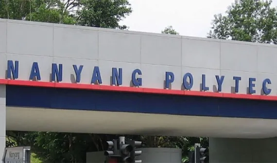
News Esri Singapore, Nanyang Polytechnic unveils first ArcGIS lab in Singapore Esri Singapore has signed a three-year partnership with the Nanyang Polytechnic (NYP), School of Information Technology. Learn more