As the situation surrounding COVID-19 continues to evolve, Esri Indonesia is taking pro-active steps to ensure continuity of services and support to our user community. This includes our staff working remotely to ensure the geospatial systems and applications in your organization remain fully supported during this period. As such, our clients and partners can be confident that – regardless of what unfolds – our commitment to your priorities remains unwavering.
Emergency Spatial Support Centre
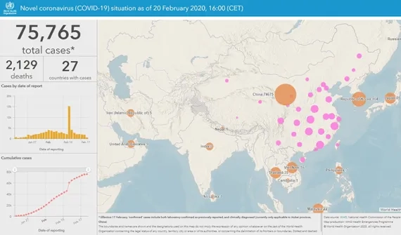
Furthermore, as part of efforts to support the wider community, Esri Indonesia’s Emergency Spatial Support Centre has developed a geoportal that maps the COVID-19 situation in the country as it unfolds. The portal provides users with easy access to authoritative maps, datasets and apps on the virus thereby helping people understand the impact of the outbreak.
If you have data or solutions that would be useful to others, we encourage you to share them with us, so we can include them in the geoportal.
Additional support
Should you have any queries regarding any of our products, services or our Emergency Spatial Support Centre, please send us an enquiry and a member of our team will respond shortly.
Alternatively, if you require technical support, please submit a technical support request (Bahasa or English) or message us via Whatsapp on (0815) 1037 7222.