GeoAI and GIS deliver actionable insights and inform decision making. Join industry leaders to discover how AI-enabled workflows enhance operational efficiency and drive growth.
Agenda
- 09:00 | Enabling Indonesia 4.0 with GeoAI technology
Hear how GeoAI enables Indonesia 4.0 and how actionable intelligence helps create a smarter, sustainable future in today's complex world.
- 09:20 | Keynote: Accelerating national base map scaling with GeoAI
Presenter: Ade Komara Mulyana, Head of the Centre for Topographic Mapping and Toponym, Geospatial Information Agency
As Indonesia continues to develop its base maps, hear how advanced technologies can support the implementation of higher map scales and integrate various thematic maps with official base maps that can eventually be synchronised into a single reference.
- 09:50 | Keynote: Approaching Indonesia's development with data and GeoAI
Presenter: Nazib Faizal, Head of Data Center and Information Technology at the Ministry of Public Works and Housing
Following the implementation of an end-to-end framework to manage and modernise Indonesia’s highway infrastructure, Nazib Faizal now heads the Ministry of Public Works and Housing Data Center and Information Technology with a mandate to modernise the nation’s infrastructure. Hear how IoT data, machine learning and CCTV can be integrated to enable better planning, maintenance, operations and infrastructure investments.
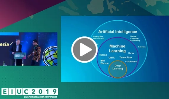
- 10:35 | Trends in GeoAI
New capabilities in GeoAI
Presenter: Esri Indonesia team
Explore GeoAI capabilities and their applications across multiple industries with the Esri Indonesia team, including:
- Data capture and analysis
- Understanding and validating incident reports from social media
- Collaboration and sharing
Plantation management with AI
Presenter: Tri Haryo Sagoro
Wilmar International is using geospatial data and AI to plan, analyze and monitor palm oil operations on the ground. Hear how advanced technologies enable decision makers to understand plant health conditions, mitigate risk and control the spread of infestations to protect any plantation’s most valuable asset.
A new benchmark in highway asset management
Presenter: Prayogi Setyo Pratomo
Managing one of the main distribution and public transportation channels in West Java, Astra Tol Cipali’s Highway Pavement Management System tracks asset health, visualises location and supports asset network maintenance by leveraging GeoAI.
Hear how the company is setting the benchmark for highway asset management and explore am innovative approach to asset management and monitoring
- 11:45 | Closing remarks
The adoption of artificial intelligence requires a collaborative effort between government, private sector, academia and innovators across the country to effectively contribute to Indonesia's advancement. In his closing remarks, Christanto Yanuar outlines next steps in the development of future technologies that support the economic wellbeing of Indonesians.
- 12:15 | Application showcase
12:15 – 12:30 | Smart urban planning and community engagement
Presenter: Soraya Rizka Keumala, Solution Specialist, Esri Indonesia
As issues like housing availability, sustainability goals and economic changes force cities to plan better for the future, planners and design professionals turn to 3D applications like ArcGIS Urban to collaborate across teams and assess impacts of proposed plans.
Discover how advanced visualisation technology can accelerate policy making with scenario-driven process to create land-use plans, update zoning codes, and evaluate development proposals — and how to communicate plans with various audiences and stakeholders through an interactive 3D urban model.
12:30 – 12:45 | Graph data analytics
Presenter: Muhammad Azmi, Solution Engineer, Esri Indonesia
Any crime involves multiple locations of suspects, dealers, traffickers, buyers, entry ports and more. To solve these cases, investigators look to hidden patterns and connections between all the evidence and data points. Discover how to run graph analysis using ArcGIS Knowledge and understand how to combine spatial and non-spatial data to reveal patterns and hidden insights to inform decision-making.
12:45 – 13:00 | Spatial real-time data pipeline architecture
Presenter: Fepro Putra Panghurian, Senior GIS Application Developer, Esri Indonesia
Go beyond basic spatial analysis with immediate access to advanced statistical tools and specialised geoanalytics functions. Get the diverse perspectives you need to make better-informed decisions with big spatial data.
13:00 – 13:15 | Imagery and GIS: A geospatial system for imagery driven insights
Presenter: An Nisaa Citra Hasanah, Solution Engineer, Esri Indonesia
Discover the insights you can derive by analyzing images with geospatial technology. Watch Citra unpack information from every pixel and transform static images into dynamic digital representations of our world.
13:15 – 13:30 | Spatial broadcasting for public administration engagement
Presenter: Pachira Eizza Paramitha, Solution Engineer, Esri Indonesia
Today’s government services are enhanced and expedited with real-time technology. Explore how the spatial broadcasting for public administration engagement solution improves government service delivery.