Home

Main navigation

  • Industries
    • Commercial
      • Agriculture and plantation
      • Architecture, engineering and construction
      • Banking and financial services
      • Electricity
      • Forestry
      • Gas
      • Manufacturing
      • Market development
      • Media
      • Mining
      • Petroleum
      • Property and real estate
      • Retail
      • Telecommunications
      • Transportation and logistics
      • Water
    • Government
      • Solutions for government
      • Cities and municipalities
      • Defence and intelligence
      • Emergency and disaster response
      • Infrastructure and public works
      • Land administration
      • National government
      • Provincial government
      • Spatial data infrastructure
    • Community
      • GIS for schools
      • Internship Program
      • Freedom to Learn Programme
      • Future Leader Program
      • Esri Young Scholars Award
      • Non-profit
  • Products
    • About ArcGIS
      • What's new in ArcGIS
      • ArcGIS Online
      • ArcGIS Desktop
      • ArcGIS Pro
      • ArcGIS Enterprise
      • ArcGIS Platform
      • ArcGIS for Developers
      • ArcGIS for Personal Use
      • ArcGIS platform free trial
      • Esri CityEngine
      • ArcGIS Urban
    • ArcGIS Apps
      • Apps for the office
      • Field Operations
      • Apps for the community
      • App Builders
    • Harris Geospatial
      • ENVI
      • IDL
      • ENVI SARscape
      • Jagwire
      • Helios
      • AMPlify
      • Geospatial Services Framework
    • Data
      • GIS data
      • Open Data
      • Data Interoperability
      • Open Standards
      • Esri’s Open Vision
  • Services and support
    • Services
      • Professional services
      • Implementation services
      • Managed Cloud Services
    • Technical support
      • Resolving incidents
      • Support FAQs
      • Esri platform resources
      • Support maintenance
      • Support request (English)
      • Support request (Bahasa)
    • Training
      • Training calendar
      • Training courses
      • Training FAQs
      • Virtual Classroom Training
    • COVID-19 assistance
      • Esri Disaster Response Program
      • Business Continuity Solution
      • ESSC COVID-19 resources hub
      • COVID-19 cases dashboard
      • DRP support (English)
      • DRP support (Bahasa)
  • News and events
    • News
      • Subscribe to news
      • Media and PR enquiry
      • Directions podcast
      • Mapping Evil podcast
    • Blogs
    • Events Calendar
      • Webinars
      • UC presentations
      • Past event presentations
  • About
    • Esri Indonesia
      • Our people
      • Our history
      • Our relationship with Esri
      • Our relationship with Boustead
      • Our partner program
      • Careers
    • GIS technology
      • About Esri
      • Jack Dangermond
      • History of GIS
      • About location analytics
      • Esri map gallery
    • Contact us
      • General enquiries
      • Sales
      • Services
      • Training
      • Support request (Bahasa)
      • Support request (English)
      • Media
      • Subscribe
  • Store

You are here

  • Industries
  • Commercial
  • Media

GIS in media

Maps and analytics deliver greater insight and take media communication to the next level.

CNN Indonesia maps global terror
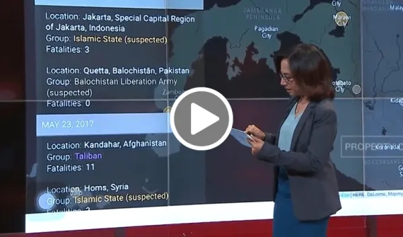
Video CNN Indonesia maps global terror

CNN Indonesia uses an interactive story map to give a more compelling view of the terror attacks happening around the world.

More
Kompass Daily transforms storytelling with location analytics
Case study Kompass Daily transforms storytelling with location analytics

Indonesian print media giant, Kompas Daily, is using location-based analytics to create credible content for its growing readership.

More

To learn more about the role of GIS in media, please email us or call on (021) 2940 6355.

Bringing smart maps to the masses news
Case study Bringing smart maps to the masses

For Channel Seven and Yahoo!7, Australia's leading free-to-air network and top-rated news service, the 2013 Federal elections represented an opportunity to reinvent traditional political news coverage.

More
Seven News maps driving offence hot spots news
News Seven News maps driving offence hot spots

Seven News has used GIS technology to reveal Queensland suburbs with the highest number of serious driving offences.

More
Media company delivers location intelligence news
Blog Media company delivers location intelligence

The Start Tribune offers prospective advertisers GIS-based consultations on how to find customers and grow their business.

More

Subscribe to
Esri Indonesia news


Footer menu

  • Sitemap
  • Privacy
  • Disclaimer

© 2021 Esri Indonesia All rights reserved.