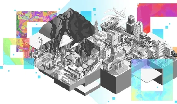
GIS is empowering decision-makers and field workers in the mining sector to increase production, optimise workflows, and mitigate risk.
ArcGIS solutions for mining
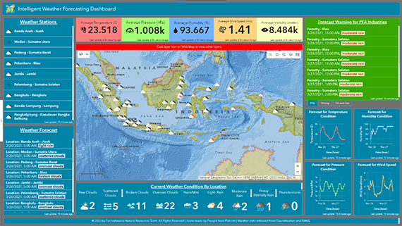
Intelligent weather forecasting and alerting
Access comprehensive information on current weather, trends over time, and forecasts for different locations to support daily operations.
- Improve productivity and planning for weather-related operations
- Maintain safety by accurately aligning planning forecast data for safer operations
- Avoid excess operational costs by accurately creating work plans
Products
- ArcGIS Enterprise standard (or above) or ArcGIS Online
- ArcGIS Pro standard or above for schema design and publishing
- ArcGIS API for Python for automation
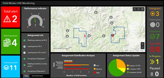
Real-time Data Monitoring and Field Apps Integration
Monitor Health, Safety and Environment (HSE) alerts in real-time and integrate mobile apps for fieldwork activities.
- Track fieldworkers and heavy-weight vehicles in real time
- Monitor HSE alerts for field activities in hazardous or restricted areas
- Dispatch field assignments and monitor their status
- Collect and submit data from the field
- Visualize data and analyze fieldwork Key Performance Indicators (KPI)
Products
- GeoEvent Server (for real-time data monitoring)
- ArcGIS Workforce
- ArcGIS Survey123
- ArcGIS Dashboard
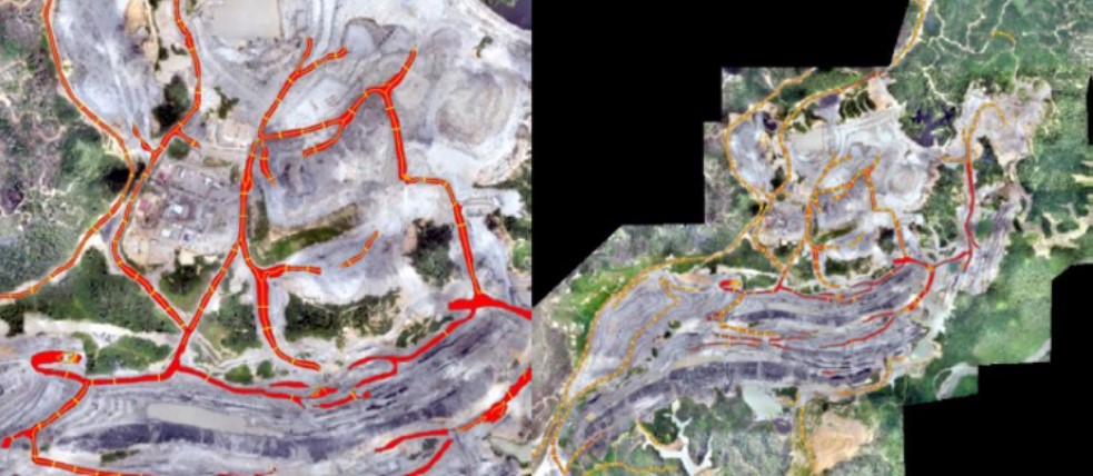
Road Extraction and Alerting on Imagery
Extract road features from imagery and automate road width and slope alerts using GeoAI.
- Undertake labelling for bimodal classification
- Develop training with Machine Learning classifier (Random Forest) and raster classification
- Export training data for Deep Learning
- Perform Deep Learning Modelling (U-Net)
- Run model inference using pixel classification
- Raster refinement and feature conversion
Products
- ArcGIS Pro
- Spatial Analyst extension for ArcGIS Desktop
- Image Analyst extension for ArcGIS Desktop
To learn how to apply the latest GIS technology to your organization, book a consultation with one of our solutions experts.
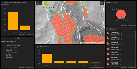
Mining Area Management and Productivity Analysis
Map and monitor blocks, pit, disposal, run-of-mine (ROM), and other areas on mining sites using ArcGIS Dashboard.
- Map and monitor mining sites
- Analyse daily/weekly productivity or operations
- Integrate datasets such as blockstrip, pit, disposal, ROM and other boundaries, road network, DEM (Digital Elevation Model), and more
Products
- ArcGIS Pro
- Spatial Analyst extension for ArcGIS Desktop
- ArcGIS Dashboard
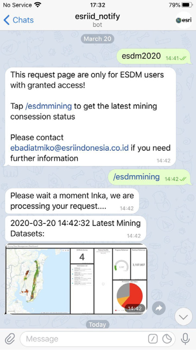
Data and Map Access on Mobile Chat Application
Respond to data queries and run analysis using mobile chat applications.
- Query data via chat app
- Analyse data on the go
- Update system data via an app
- Retrieve alert notifications remotely
Products
- ArcGIS Pro
- Spatial Analyst extension for ArcGIS Desktop
- ArcGIS Dashboard
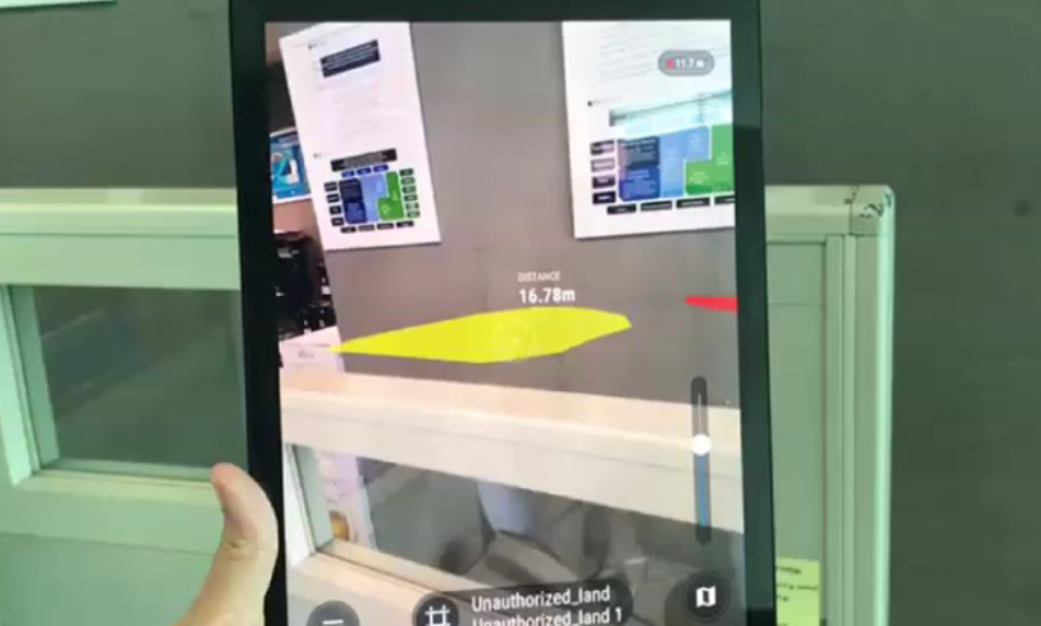
Augmented Reality meets GIS in a Mobile App
Monitor fieldworkers in real-time using augmented reality (AR) and ensure field safety implementation.
- Maintain real-time information on field worker locations
- Monitor field data submission on restricted areas, such as areas prone to landslide, preserved forests, unauthorised land, etc.
- Visualise alerts to enable managers to track field workers and support field safety
Products
- ArcGIS Online
- GeoEvent Server (for alerts)
- ArcGIS Survey123 (for field data submission)
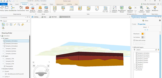
Interactive Slicing of Geological Layers and Fence Diagram
Analyse subsurfaces by building geological fencing from Triangulated Irregular Network (TIN) data layers.
- Perform geological analysis
- Explore potential sites
- Plan operational activities
- Assess the risks of potential hazards (e.g. landslides, earthquakes, etc.)
- Develop infrastructure at mining sites
Products
- ArcGIS Pro
- Spatial Analyst extension for ArcGIS Desktop
- 3D Analyst extension for ArcGIS Desktop
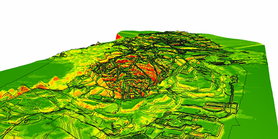
Slope Interpolation and Geological Faults Delineation
Interpolate points in 3D to visualise slope layers from point cloud data using Empirical Bayesian Kriging (EBK).
- Interpolate point cloud data to produce slope layers
- Delineate faults on steep slopes
- Identify safe roads for mine transportation, cut-fill planning, landslide risk assessment, etc.
Products
- ArcGIS Pro
- Spatial Analyst extension for ArcGIS Desktop
- 3D Analyst extension for ArcGIS Desktop
Mine Site Revegetation and Mine Rehabilitation
Increase time efficiency for regular revegetation monitoring and automation processes.
- Undertake tree counting
- Classify tree species
- Measure vegetation area size
- Automate the monitoring of revegetation programs
Products
- ArcGIS Pro
- Spatial Analyst extension for ArcGIS Desktop
- Image Analyst extension for ArcGIS Desktop
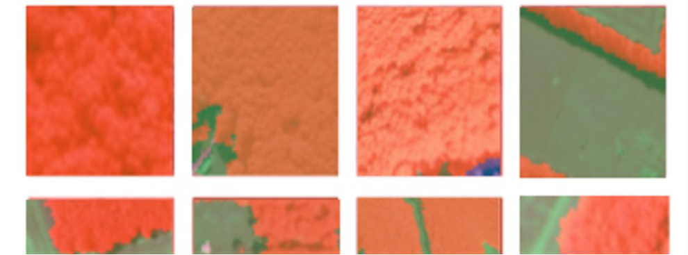
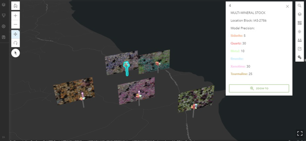
Mineral Classification and Counting using AI
Improve efficiency of image analysis to accurately identify mineral types and concentration.
- Classify minerals
- Automate the counting of mineral samples
- Locate mineral sample collections on maps
- Visualise mineral classification and counting results in 3D
Products
- ArcGIS Pro
- Spatial Analyst extension for ArcGIS Desktop
- Image Analyst extension for ArcGIS Desktop
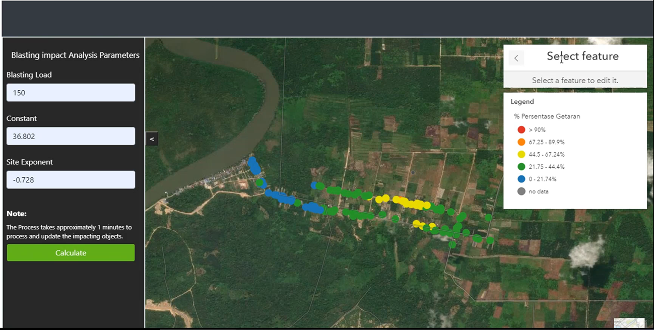
Blasting Impact Analysis Web Application
Calculate the impact of blasting based on pre-defined parameters using a web application.
- Analyse blasting impacts using a web tool
- Calculate blasting PPV (Peak Particle Velocity)
- Locate and count impacted buildings
Products
- ArcGIS Pro advanced
- Spatial Analyst extension for ArcGIS Desktop
- ArcGIS Online / ArcGIS Enterprise
Interactive Map for Mining Operation Monitoring
Monitor daily operations through an interactive map, including pit reserve volume,
ROM and disposal capacity, blasting activity and coal inventory.
- Web application and tools for daily inventory calculations of operational activities
- Locate the daily activities of mining operations
- Facilitate data uploads
Products
- ArcGIS Desktop
- ArcGIS Enterprise
- ArcGIS Developer
- Spatial Analyst extension for Desktop
- 3D Analyst extension for Desktop
- Production Mapping extension for Desktop
- Product Mapping extension for Server