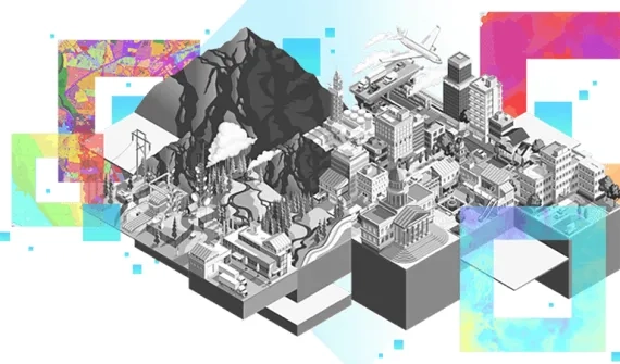
Emergency and disaster management agencies leverage powerful mapping and analysis capabilities to proactively identify risks and develop effective mitigation and response plans.
Explore the specific solutions supporting emergency and disaster management operations below.
Industry solutions catalogue
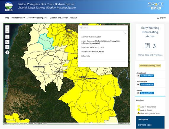
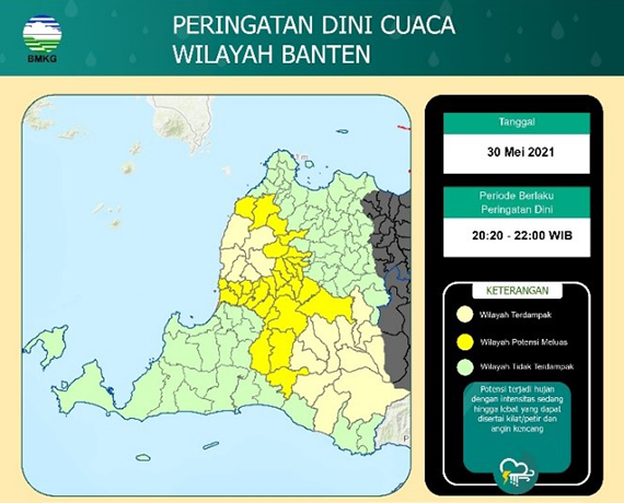
Early warning nowcasting
Disseminate accurate early warning nowcasting quickly to protect communities.
Ideas and insight:
- Monitor real-time early warning nowcasting in active areas
- Share consolidated information on a publicly-accessible, web-based platform
- Convey real-time information on crisis areas
Product mix:
- ArcGIS Enterprise advanced, including ArcGIS Dashboards
- ArcGIS Pro on ArcGIS Desktop standard
- GeoEvent Server extension for Server
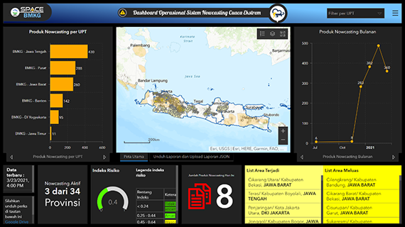
Automated verification and nowcasting dissemination
Increase awareness across the community and allow valuable information to be shared with the click of a button.
Ideas and insight:
- Automatically verify active areas
- Generate warning infographics to share on social media
- Manage and approve information sharing via Telegram
Product mix:
- ArcGIS Enterprise advanced
- ArcGIS Pro on ArcGIS Desktop advanced, including ArcGIS API for Python
- Spatial Analyst extension for ArcGIS Desktop
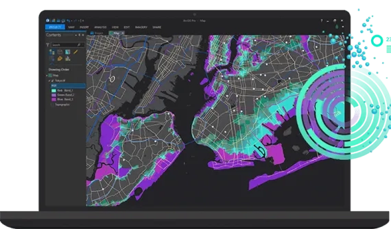
Extreme weather monitoring
Connect to internal Web-GIS systems and build centralised information platforms to share nowcasting information and enable extreme weather monitoring in remote locations.
Ideas and insight:
- Utilise weather data for internal planning and processes
- Collect and monitor weather data in real-time using dashboards
- Set up alerts for relevant active extreme weather events
- Leverage an easy-to-use extreme weather reporting platform
Product mix:
- ArcGIS Enterprise advanced, including ArcGIS Dashboards
- ArcGIS Pro on ArcGIS Desktop standard
- Spatial Analyst extension for ArcGIS Desktop
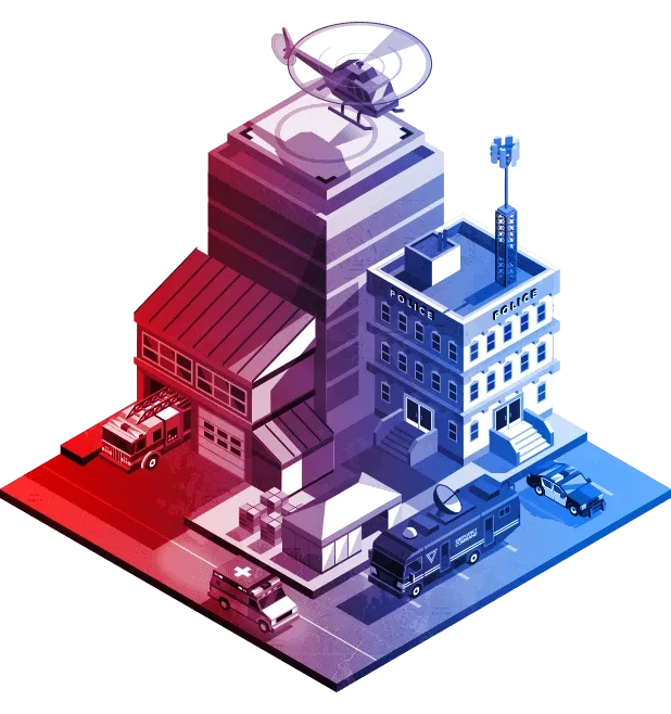
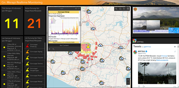
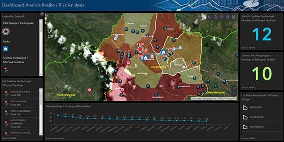
Emergency real-time data monitoring
Real-time GIS monitoring of disaster events enables stakeholders to analyze risks and evaluate impacts to save lives and protect assets.
Ideas and insight:
- Monitor disasters in real-time
- Monitor weather in real-time
- Keep communities informed
- Update embedded social media accounts automatically
Product mix:
- ArcGIS Enterprise advanced, including ArcGIS Dashboards
- GeoEvent Server extension for ArcGIS Server
- ArcGIS Pro on ArcGIS Desktop standard
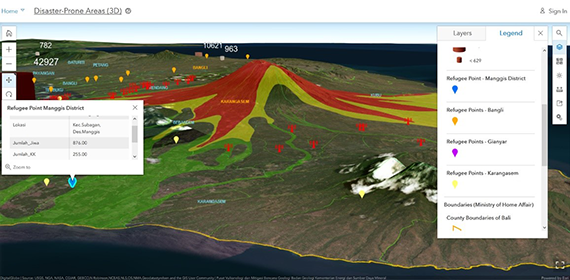
3D analysis and evacuation planning
Prioritise the determination of evacuation routes to assist those impacted by disasters quickly.
Ideas and insights:
- 3D visualisation of disaster-prone areas
- Assess evacuation needs
- Determine best evacuation routes
Product Mix:
- ArcGIS Enterprise advanced
- ArcGIS Pro on ArcGIS Desktop standard
- Network Analyst extension for ArcGIS Desktop
Damage reporting and analysis
Integrate field data to enhance analysis and enable informed decision-making.
Ideas and insights:
- Manage field data collection effectively and efficiently
- Leverage paperless damage reporting mobile applications
- Record locations, attributes, and photos or videos of damage quickly and easily to inform reporting
- Monitor field data collection in real-time from the office
Product mix:
- ArcGIS Enterprise advanced, including ArcGIS Survey123
- ArcGIS Dashboards
- ArcGIS Pro on ArcGIS Desktop standard
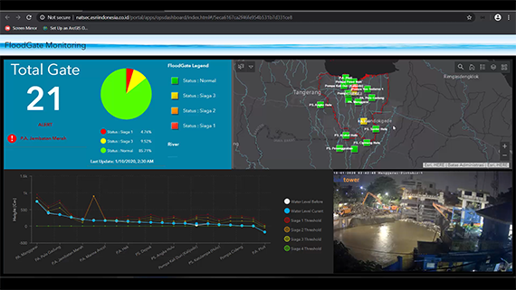
Real-time floodgate monitoring
Used to accelerate decision-making and response to flood disasters, floodgate monitoring provides location-based intelligence from all connected floodgates.
Ideas and insight:
- Monitor current flood levels in real-time
- Display floodgate conditions via CCTV in real-time
- Share emergency alerts and mobile app notifications (Telegram) on floodgate status
Product mix:
- ArcGIS Enterprise advanced, including ArcGIS Dashboards
- GeoEvent Server extension for ArcGIS Server
- ArcGIS Pro on ArcGIS Desktop standard
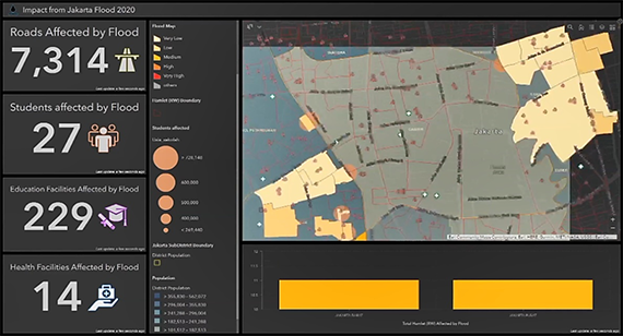
Impact analysis and 3D visualisation
In addition to submerging hundreds of kilometres of roads, flooding also widely impacts public facilities such as hospitals, schools, malls and landmarks.
Ideas and insight:
- Map flood-impacted areas
- Maintain 3D visualisation of flood levels
- Minimise losses and support organised response and evacuation efforts
Product Mix:
- ArcGIS Enterprise advanced, including ArcGIS Dashboards
- ArcGIS Pro on ArcGIS Desktop standard
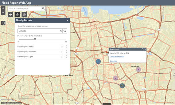
Damage reporting for public use
A more direct approach to collecting and processing data quickly, especially in the event of a flood.
Ideas and insight:
- Manage field data collection effectively and efficiently
- Leverage paperless damage reporting mobile applications
- Record photos or videos to show locations and damage attributes quickly and easily – and support reporting requirements
- Monitor field data collection in real-time from your office
Product mix:
- ArcGIS Enterprise advanced, including ArcGIS Survey123 and ArcGIS Web AppBuilder
- ArcGIS Pro on ArcGIS Desktop standard
COVID-19: Vaccination centre accessibility
Evaluate accessibility of COVID-19 vaccination centres and healthcare facilities measured by drive time.
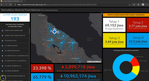
Ideas and insight:
- Utilise demographic data to determine vaccination phase distribution
- Measure drive time
- Visualise data using maps and charts in a web dashboard
- Interactively engage public by sharing valuable information
Product mix:
- ArcGIS Pro on ArcGIS Desktop standard
- Network Analyst Extension for Desktop
- ArcGIS Online, including ArcGIS Dashboards
COVID-19: Quarantine facility mapping
Record and disseminate information about quarantine facilities to assist COVID-19 patients.
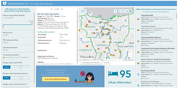
Ideas and insight:
- Categorise facilities by price, city, medical services, catering services, and more
- Create web applications for both desktop and mobile - no coding required
- Collect crowd-sourced data using online survey forms
Product Mix:
- ArcGIS Pro on ArcGIS Desktop standard
- ArcGIS Online, including ArcGIS Dashboards, ArcGIS Survey123 and ArcGIS Experience Builder
Forest and land fire detection
Nearly all forest and land fires in Indonesia are caused by people, making monitoring a difficult task. AI and geospatial technology can identify when and where a fire occurs and map impacted areas to inform response strategies.
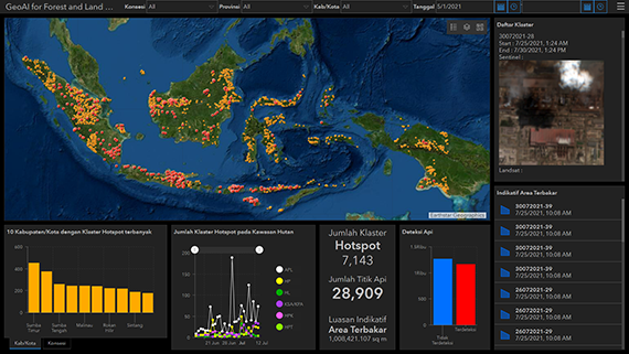
Ideas and insight:
- Identify hotspots indicating the most probable location of forest and land fires
- Identify active burned land to measure impacted areas
- Implement near real-time automation workflows to get immediate results
Product Mix:
- ArcGIS Enterprise advanced
- Image Server extension for ArcGIS Server
- ArcGIS Pro for ArcGIS Desktop advanced
- Spatial Analyst extension for ArcGIS Desktop
- Image Analyst extension for ArcGIS Desktop
- Imagery Services