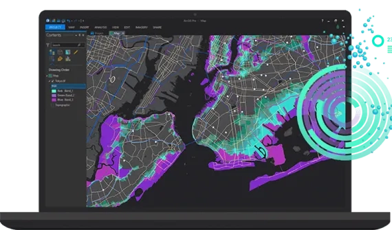

GIS is empowering decision-makers, field workers and consultants to strengthen timber investment and natural resource management by maximising the value of timber assets and reducing costs.
ArcGIS solutions for forestry
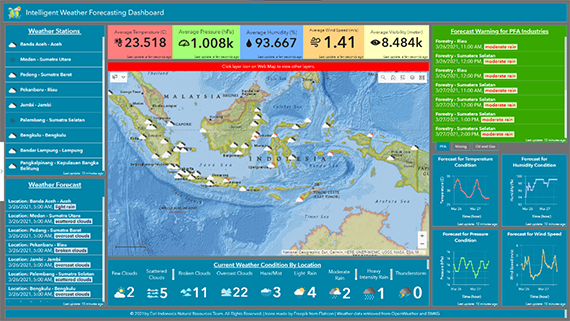
Intelligent Weather Forecasting and Alerting
Access comprehensive information on current weather, trends over time, and forecasts for different locations to support daily operations.
-
Improve productivity and planning for operations impacted by weather events
-
Align planning and forecast data to maintain operational safety
-
Create accurate workplans to avoid excess operational costs
Products
- ArcGIS Enterprise standard (or above) or ArcGIS Online
- ArcGIS Pro standard or above for schema design and publishing
- ArcGIS API for Python for automation
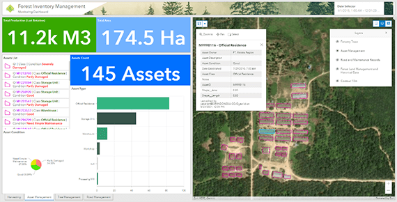
Forest Inventory Management
Visualise and monitor forest inventory data with location intelligence to provide better insights on current inventory detail, status, and condition.
- Integrate spatial data and production data
- Visualise production data in a map-based view
- Easily monitor historical production and other operational data using map-based charts and diagrams
- Directly monitor achievements against set targets
- Customise map symbology based on productivity, cost, or other data
Products
- ArcGIS Enterprise standard (or above) or ArcGIS Online
- ArcGIS Pro standard or above for schema design and publishing
- ArcGIS Spatial Analyst
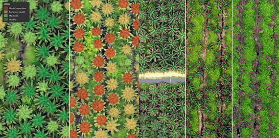
Tree Counting, Blank Spot Detection, Change Detection and Post Advance Analysis using Deep Learning
Use deep learning for scalable, accurate and fast tree detection and undertake further analysis of health, or detect changes or blank spots.
- High accuracy tree detection using deep learning workflow
- Analyse tree health directly from drone imagery
- Accurately estimate crown size of all trees to plan maintenance and other operations
- Run regular tree detection and compare results to detect changes
- Easily detect blank spot areas
- Easily increase and decrease computing resources for faster processing
Products
- ArcGIS Desktop or ArcGIS Pro
- ArcGIS Spatial Analyst
- ArcGIS Image Analyst
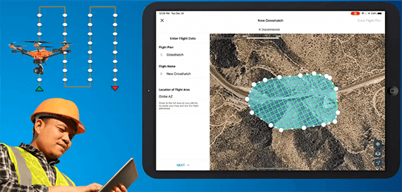
End-to-end Drone Imagery Data Collection and Processing Workflow
Drone imagery provides better visualisation of assets, trees, land and other objects and can be used for further image analysis or deep learning workflows.
- Product 2D image maps (orthomosaics), 3D elevation products and oblique inspection photos
- Plan and manage drone flights to support project requirements
- Publish drone mapping products to ArcGIS Online, ArcGIS Enterprise, and Autodesk BIM 360
- Easy to use end-to-end workflow
Products
- ArcGIS Site Scan Flight Planner
- ArcGIS Site Scan Cloud Processing or Drone2Map (On-Premises)
Real-time Fleet Movement Tracking and Monitoring
Analyse fleet routes, fuel consumption and idle time by integrating real-time sensor data with GIS to identify opportunities for optimisation.
- Monitor fleets and other moving assets in real-time
- Receive notifications for speed, over-acceleration, and unsafe driving
- Measure volume, start and destination points, fleet capacity and distance between facilities to optimise schedules
![]()
Products
- ArcGIS Enterprise standard (or above) or ArcGIS Online
- ArcGIS GeoEvent Server for real-time data processing
- ArcGIS Pro standard or above for schema design and publishing
- ArcGIS Python API for customised reporting
Integrated Fleet Dispatching, Tracking and Monitoring for Fleet Management
Easily dispatch fleets from a web application, send notifications to fieldworkers, and monitor movements in real-time.
![]()
Products
- ArcGIS Enterprise standard (or above) or ArcGIS Online
- ArcGIS Pro standard or above for schema design and publishing
- ArcGIS Field Maps for fleet tracking
- ArcGIS Workforce for dispatching
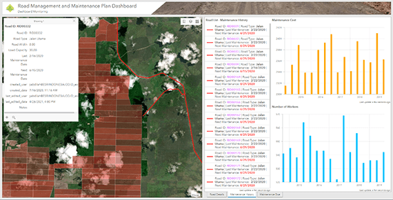
Road Management and Maintenance Plan Using Location Intelligence
Visualise road networks to analyse road conditions and maintenance schedules, and gain insights to improve efficiency.
- Visualise road networks, including road conditions and maintenance plans
- Access integrated mobile apps to capture road conditions with photo submissions directly from the field
- Streamline prioritisation of road maintenance activities
Products
- ArcGIS Enterprise standard (or above) or ArcGIS Online
- ArcGIS Pro standard or above for schema design and publishing
- ArcGIS Field Maps for field data reporting
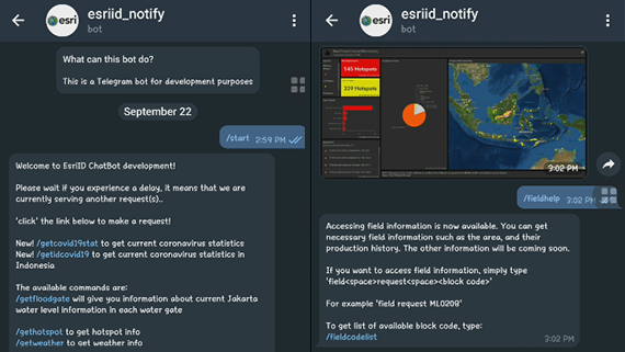
Telegram Chatbot for Handling Data Query and Quick Accessibility
Quickly access information through Telegram, by sending a command to a chatbot to receive a reply with current dashboard information.
- Easily access dashboards and apps through Telegram using commands
- Easily query data from portal feature service
- Set security rules to filter unauthorised requests
- Access most recent data from dashboards or web app snapshots
- Request asset status information including plantation block production, truck location, fleet status
Products
- ArcGIS Enterprise standard (or above) or ArcGIS Online
- ArcGIS Pro standard or above for schema design and publishing
- ArcGIS API for Python for automation
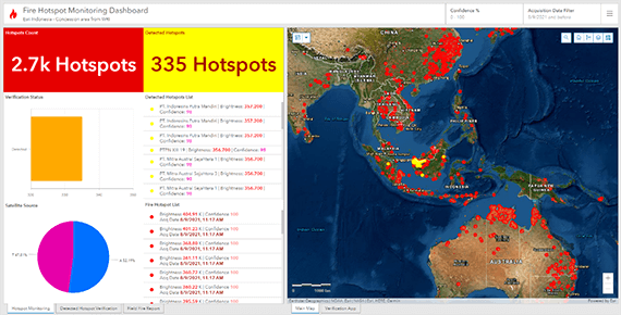
Automatic Detection and Alert of Hotspots in Forestry Concession Areas
Access real-time reports and alerting on current hotspots to help fire crews verify and prepare for potential fires in the area.
- Real-time fire hotspot updates directly from MODIS and VIIRS satellites (15-minute refresh rate)
- Automatically crawl fire hotspot data to database and detect hotspots inside or near concession areas
- Automatically trigger notifications to field crow through email or Telegram
- Easy-to-use form for hotspot verification (web-based or smartphone app)
Products
- ArcGIS Enterprise standard (or above) or ArcGIS Online
- ArcGIS Pro standard or above for schema design and publishing
- ArcGIS API for Python for automation