
Explore the transformational role of GIS in government and discover digital solutions that help analyze and solve complex administrative problems — from social welfare to tax revenue management and streamlined service delivery.
Industry solutions catalogue
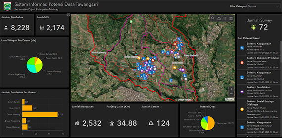
Social welfare information system
Monitor and manage the distribution of social assistance efficiently with a structured data management system and detailed information on available funds and the location of beneficiaries.
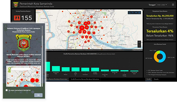
Ideas and insights:
- Maintain a repository of regional poverty data
- Monitor the distribution of funds
- Analyze the location of beneficiaries
Product mix:
Tourism information system
Manage tourism activities efficiently and generate more revenues for your region.
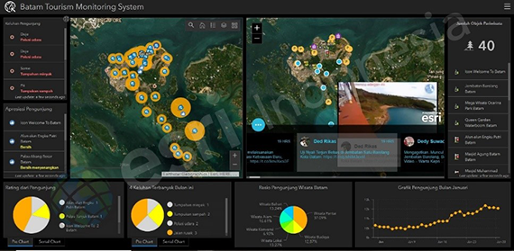
Ideas and insights:
- Manage tourism data analysis
- Promote and disseminate local tourism information
- Monitor visitor numbers and feedback
Product mix:
- ArcGIS Online or ArcGIS Enterprise
- ArcGIS Pro
- ArcGIS Hub
- ArcGIS Experience
- ArcGIS Web AppBuilder
- ArcGIS Dashboards
Epidemiological surveillance dashboard
Integrate epidemiological surveillance data with location information to visualise populations, monitor disease and maintain healthy communities.
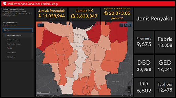
Ideas and insights:
- Visualize epidemiological surveillance data on a map
- Monitor the spread of disease by location and numbers
- Share information easily with the community
Transportation infrastructure maintenance
Manage transportation facilities and infrastructure efficiently using a structured data management system to drive sustainable urban development.
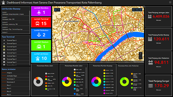
Ideas and insights:
- Manage transportation infrastructure geospatial data
- Monitor transportation infrastructure with dashboards
- Update asset data using mobile field applications
- Enhance transportation infrastructure maintenance and involve the community in damage reporting and mapping
Crime management
Map and monitor crime incidents by location using a GIS application.
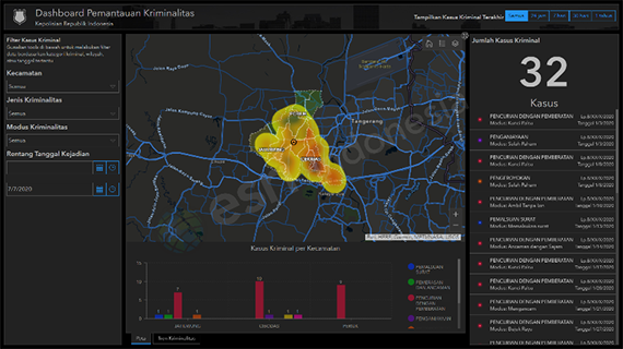
Ideas and insights:
- Provide police with crime report statistics
- Analyze crime density
- Monitor crime incidents
- Enable field data collection and submission
Product mix:
- ArcGIS Desktop
- ArcGIS Online / ArcGIS Enterprise
- ArcGIS Survey123
- ArcGIS Web AppBuilder
- ArcGIS Dashboards
Environmental and forest management
Manage, monitor and protect forest areas using GIS applications.
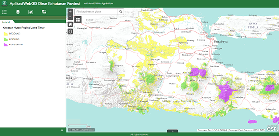
Ideas and insights:
- Enable data gathering and sharing with Forestry Department database
- Forestry land assets and commodities inventory
- Hotspot monitoring and illegal logging report
- Field data collection and submission for asset inventory, surveys and forest condition reporting
Product mix:
- ArcGIS Online or ArcGIS Enterprise
- ArcGIS Desktop
- ArcGIS Survey123
- ArcGIS Web AppBuilder
- ArcGIS Dashboards
Residential development planning
Create a database of residential properties, monitor uninhabitable locations and analyze the development potential in each area using GIS applications.
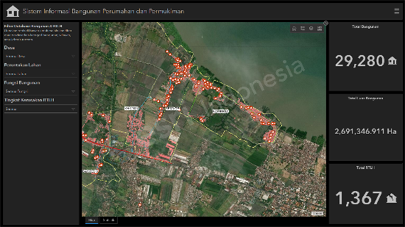
Ideas and insights:
- Determine suitability of priority areas for new housing development plans
- Monitor housing and settlement databases
- Analyze the concentration of uninhabitable properties in a given area
- Enable field data collection and submission
Product mix:
- ArcGIS Online or ArcGIS Enterprise
- ArcGIS Desktop
- ArcGIS Spatial Analyst extension
- ArcGIS 3D Analyst extension
- ArcGIS Survey123
- ArcGIS Web AppBuilder
- ArcGIS Dashboards
Licensing information system
Leverage the capabilities of GIS technology to optimise public services for licensing.
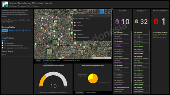
Ideas and insights:
- Manage permits
- Streamline licensing for faster and easier service delivery
- Avoid overlapping interests by overlaying RTRW (regional spatial plan) data on permit applications
Product mix:
Revenue information system
Enable regional revenue services to map local revenue sources including taxes, levies and wealth management.
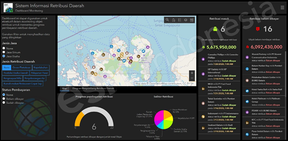
Ideas and insights:
- Identify tax objects using smart surveys
- Provide an overview of local revenue sources
- Maintain a complete record of revenue sources including value, targets and unpaid taxes
Parking information system
Manage city parking and estimate revenues.
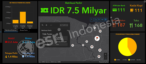
Ideas and insights:
- Maintain an overview of all parking facilities
- Manage parking occupancy and revenues
- Analyze parking behaviours and patterns
Product mix:
- ArcGIS Online or ArcGIS Enterprise
- ArcGIS Pro
- ArcGIS Maps for Office
- ArcGIS Dashboards
Smart city information system
Visualise potential and plan your smart city development.
Ideas and insights:
- Provide stakeholders with valuable information on development plans
- Share financial reports and maintain transparency with stakeholders
- Monitor development potential
- Enable field data collection and submission
Product mix:
- ArcGIS Online or ArcGIS Enterprise
- ArcGIS Desktop
- ArcGIS Survey123
- ArcGIS Web AppBuilder
- ArcGIS Dashboards
Tata Ruang information system
Visualise the Tata Ruang map using web GIS to increase public awareness of city development plans.
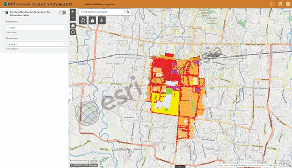
Ideas and insights:
- Visualise Tata Ruang data
- Simulate the impact of planned development
Product mix:
Waste collection services
Implement effective solutions for recording and collecting data using GIS technology and visualise your waste collection operation on a map.
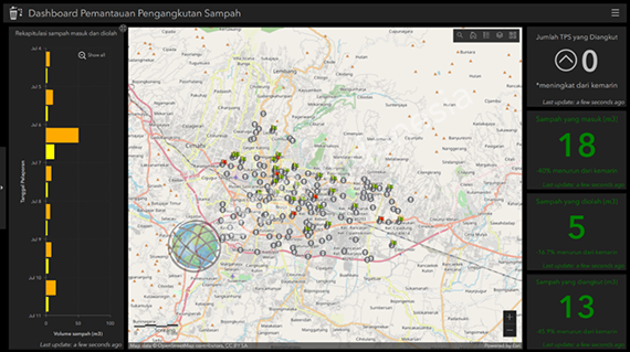
Ideas and insights:
- Integrate with waste transportation management GIS
- Adopt paperless data collection applications
- Analyze waste volumes in real-time
- Encourage two-way engagement with communities
Product mix: