
All transactions happen in a specific place – and ArcGIS solutions for retail deliver insights into why transactions happen where they do. Spatial analysis empowers retailers to make informed decisions, enrich customer experiences, select profitable sites, and increase incremental sales.
Industry solutions catalogue
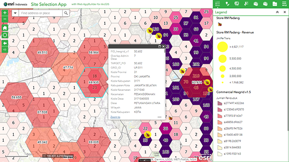
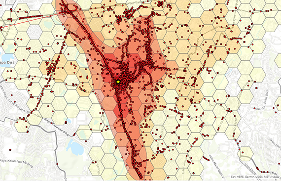
Market development – site selection
Through a powerful integration of internal and external data, retailers can access critical insights to inform market expansion plans, select and qualify new sites or evaluate the performance of existing outlet locations.
Ideas and insights:
- Access a single, integrated view of all internal and external datasets – including demographic insights and purchasing patterns
- Deploy ready-to-use location analytics tools across your enterprise
- Undertake property surveys with mobile-based field data collection apps
- Share analysis and insights with all stakeholders via interactive web maps and apps
Product mix:
- ArcGIS Online or ArcGIS Enterprise
- ArcGIS Pro 2.8
- ArcGIS Online Credits 5 Blocks
Required data:
- Point of Interest data from HERE
- Market Research data from Michael Bauer Research International
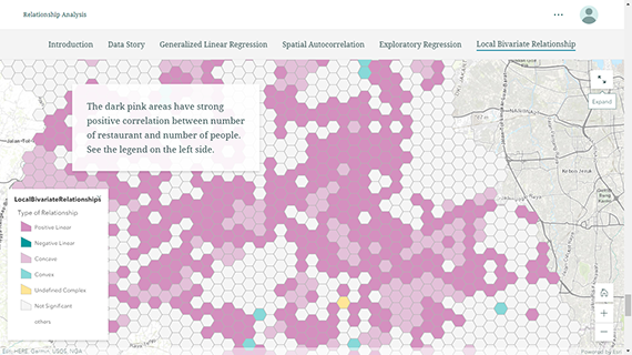
Market development – market analysis
When it comes to marketing development, business analysts need tools to uncover critical insights into sales performances. ArcGIS analyses critical business and market data with an advanced statistical approach, to equip decision-makers with all the knowledge they need to make the right business decisions.
Ideas and insights:
- Combine advanced statistical methods with powerful location intelligence
- Integrate internal with external data for deeper insights
- Deliver compelling visual representations of analysis – enable all stakeholders to clearly see insights
Product mix:
- ArcGIS Online / ArcGIS Enterprise
- ArcGIS Pro 2.8
- ArcGIS Business Analyst extension for ArcGIS Pro
- ArcGIS Network Analyst extension for ArcGIS Pro
Required data:
- Street Network dataset from HERE
- Point of Interest data from HERE
- Market Research data from Michael Bauer Research International
Sales territory and trip planning
Route-to-market teams use ArcGIS tools to effectively manage distribution of products and workforces across their sales territories. Plan and optimise your workforce’s sales routes to maximise opportunities and achieve greater operational efficiency.
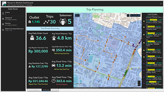
Ideas and insights:
- Optimise sales territory management
- Plan efficient routes for your workforce
- Provide plans and updates to stakeholders, anytime across any device
Product mix:
- ArcGIS Online or ArcGIS Enterprise
- ArcGIS Pro 2.8
- ArcGIS Business Analyst extension for ArcGIS Pro
- ArcGIS Network Analyst extension for ArcGIS Pro
Required data:
- Street Network dataset from HERE
- Peta Administrative Polygon from BPS
GPS movement analysis
With ArcGIS, analysts are able to identify hidden spatial patterns of how vehicles – such as buses, cars and trucks – operate through regions. Clearly see where and when incidents happen, where vehicles regularly stop, or the impacts of traffic congestion. Use this insight to better evaluate and plan your business’ daily operations.
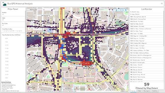
Ideas and insights:
- Deploy ready-to-use spatial analytics tools
- Prototype big data analysis methods in a desktop-based environment
- Share analysis and insights via interactive web maps and apps
Product mix:
- ArcGIS Online or ArcGIS Enterprise
- ArcGIS Pro 2.8 advanced
Commuter origin-destination modelling
Understand the travel routes of your customers – and potential customers – and use the insights to select new sites, optimise existing store performance, and deliver more targeted marketing initiatives. Analyse commuters’ ‘tap card’ travel data to visualise how your customers move through an area – including bus ridership.
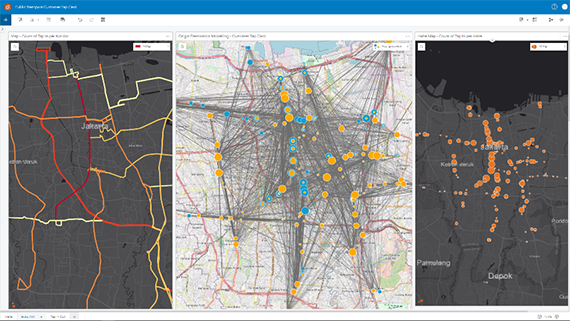
Ideas and insight:
- See your customers’ movement patterns with origin-destination modelling
- Combine your business data with external datasets on commuters and transport routes
- Inform decision-marking around store optimisation, site selection and marketing
Product mix:
Real-time monitoring for fleets
Optimise your fleet tracking system and visualise your workforce movements via real-time interactive dashboards.
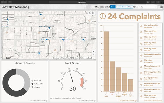
Ideas and insights:
- Track and monitor the status of your fleet in real-time
- Integrate your GIS seamlessly with your GPS-based tracking system
- Automate alerts for certain conditions or areas with ‘geofences’ and spatial filtering
Product mix:
- ArcGIS Desktop 2.8 standard
- ArcGIS Enterprise
- ArcGIS GeoEvent Server (minimum 8 cores)
People movement analysis
Sales and marketing teams can use ArcGIS to understand human movement and the impact it has on business. Easily turn telco, mobile phone and location data into actionable insights that support out-of-home marketing, selection and optimisation of trade areas, and competitor analysis programs.
Ideas and insights:
- See your customers’ movement patterns and how they interact with your retail sites
- Combine your business data with external datasets such as telco data
- Inform decision-marking around store optimisation, site selection and marketing
Product mix:
- ArcGIS Online or ArcGIS Enterprise
- ArcGIS Pro 2.8 advanced
Required data:
- People movement data