

Location intelligence rises to the challenge in a time of crisis
Geospatial data has long been used to track diseases. John Snow’s iconic mapping of cholera outbreaks in London in 1854 enabled him to identify the long misunderstood cause of the disease. Fast forward to 2014, when mapping tools and modelling were essential in the fight against the Ebola crisis in West Africa.
Today, with the ongoing COVID-19 pandemic, Geographic Information Systems (GIS) are more important than ever, offering a way to present spatial or geographic data in a meaningful way through interactive maps or other infographics.
Countless organisations now create billions of maps every day to tell stories and reveal patterns, trends, and relationships about almost any set of data you can imagine.
Naturally, to celebrate GIS this year, virtual events are the best way for geospatial communities to come together in these strange times.
Esri Indonesia has compiled a series of webinars and virtual events to get you involved in GIS Month 2020, with the theme Spatial Responses to COVID-19.


Week 1 (1-7 Nov): The GIS learning journey through COVID-19
- ArcGIS Personal Use Promo
- 5 November: In this free webinar, discover how GIS users of all ages and stages are still actively involved in geospatial learning, teaching, and mentoring.
- 7 November: Exploration Geology Workshop held by Institut Teknologi Bandung’s (ITB’s) Student Body Organisation Geology
- 7 – 8 November: Indonesian Geospatial Expert Society (IGES) Workshop. IGES (or PAGI in Bahasa Indonesia) is an association for individuals who have expertise in the field of GIS. Contact Esri Indonesia for more information.
Week 2 (8-14 Nov): Collaboration in the new normal
- 11 November: Exploration Geology for Industry: Learn how geologists are coping with the pandemic on this online talk show
- 11 November: Oil & Gas Community Virtual Event (by invitation only)
- 13 November: Universitas Tarumanagara presents a webinar on GIS for property and real estate – targeted at students and members from the urban planning sector. Contact Esri Indonesia for more information.
- 13 November: Join this free webinar on remote sensing and geospatial information: “Satellite altimetry for monitoring our earth”, featuring distinguished speakers from Universitas Mulawarman, Esri Indonesia, Universiti Teknologi Malaysia, and Ohio State University. Register Now.
- 14 November: The Indonesian Geospatial Expert Society (IGES) are hosting the webinar: “Support for thematic geospatial information in rural development”. Register now
- 14 November: Explore how you can use GIS to help economic recovery for MSMEs (UMKM) in the post-COVID-19 era in this webinar and workshop hosted by Geodesy ITB. Register now
Week 3 (15-21 Nov): GeoInnovation week
- 18 November: Take a virtual tour through the Parangtritis Geomaritime Science Park in our joint webinar with an Indonesian mapping agency in Yogyakarta. Contact Esri Indonesia for more information.
- 18 November : Mining Community Virtual Event (by invitation only)
- 19 November : Learn how GIS can guide you to success by updating the way you work: As part of its GIS Day celebrations in Kota Samarinda, Kalimantan Timur, Magisk will be conducting a private/closed GIS workshop. Find out more
- 20 November: LAST DAY FOR SUBMISSIONS: Join the Geo Innovation Challenge – a competition to discover the ground-breaking geospatial solutions that will help key local industries adapt and embrace “the new normal”
- 20 November: Discover how GIS is implemented for Planet Indonesia’s Community Health program to support conservation and socioeconomic conditions of the people living around Gunung Leuser National Park. Contribute through live donations of seeds to help conserve the area! Contact Esri Indonesia for more information.
- 20 November: GeoInnovation Award 2020 submissions extended to January '21. Great news: We have a special promotion on our ArcGIS tools! Get the ArcGIS Personal Use License at IDR 299,000 (excl. VAT; usual price IDR 549,000) and ArcGIS Online Credit Block at IDR 1,600,000 (excl. VAT; usual price IDR 2,333,000).
Simply use the following promo code upon checkout: ESRIGEOINNOVATION2020. - 21 November: Are you a student looking to apply for the right university major? You are in luck! On 21 November, the Geodesy Goes to School event – held by ITB – will take you through geodesy, mapping, and surveying, and what prospects you can expect from them! Contact Esri Indonesia for more information.
Week 4 (22-28 Nov): Economic recovery
- 24 November:Growing your agribusiness through ArcGIS Pro: In this free webinar, learn how the latest version of ArcGIS Pro can help take your plantation, forestry, and agriculture operations to a whole new level. Register now.
- 25 November: Submit a story to the 2020 ArcGIS StoryMaps Competition for Sustainable Development Goals (winners will be announced in February 2021).
- 26 November: Autodesk and Esri Webinar: Learn how the two organisations are working together to provide an environment where GIS professionals and designers and engineers can collaborate across the project life cycle by integrating GIS and BIM. Register now.
- 28-29 November: Join this sharing session and hands-on workshop by Geophysics ITB to find out more on how GIS has made an impact in the renewable energy sector. Contact Esri Indonesia for more information.
- 30 November: A GIS Day celebration held by the Timor Leste government (by invitation only)
- End of November: In a collaboration with Data Science Indonesia, Esri Indonesia will present a webinar series on how spatial data science allows analysts to extract deeper insights from data using a comprehensive set of analytical methods and spatial algorithms, including machine learning and deep learning techniques
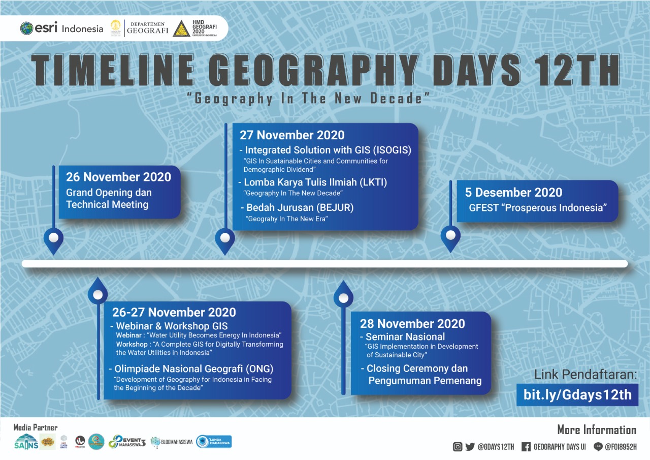
Geography Days 12th (G-Days 12th) is an annual event held by the Student Association of Geography Studies of the Faculty of Mathematics and Science, University of Indonesia (HMDG FMIPA UI).
It will be held on:
- 26 November: Join our virtual Grand Opening that includes the MoU Renewal between Universitas Indonesia and Esri Indonesia. After that, there will be a webinar on Water Utilities producing Energy in Indonesia.
- 27 November:
- Final round of the Geography National Olympiad for High School Students
- Find out more about Geography department through the Bedah Jurusan (Campus Tour) Event for high school students
- A workshop session that continues the topics covered in yesterday’s webinar on water utilities
- Scientific Writing Competition (Lomba Karya Tulis Ilmiah)
- Integrated Solution with GIS (ISOGIS): Final Round - 28 November: Last day to join us!
- Learn more about GIS being implemented within sustainable urban developments in this National Conference
- Announcing the winners of all competitions: National Geography Olympiad, Paper Competition, and ISOGIS.
- See which Indonesian university and education leader is the most influential in GIS technology at the G-Days 12th closing ceremony.
Week 5 (1-7 Dec): E-Celebration
- 1 December: A new perspective on plantation, forestry, and agriculture: In this free webinar, you’ll learn how to apply Deep Learning to your agribusiness operations. Detect objects, extract features, and analyze imagery for more efficient workflows. Register now.
- 3 December: How is a rapidly changing global landscape impacting our country’s security? Find out in this free webinar “The Indonesian Defense Strategy for the South China Sea: What if Diplomacy Fails?” with LEKOHANNAS IPWIJA. Contact Esri Indonesia for more information.
- 5 December: G-Days Virtual Music Festival